NEW: Introducing Street Editing for Podaris:Plan
Find out more...

Empowering Transport
Planners Everywhere
Transport planning, engineering, and stakeholder engagement
— seamlessly integrated in the cloud


A trusted tool for transport & development planners around the world


new
Introducing Street Editing in Podaris:Plan
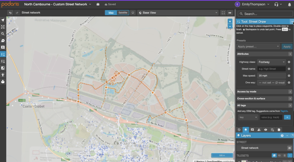
Street editing finally brings the physical network into Podaris:Plan. Now you can dynamically manipulate the network to determine a scheme's outcome: closing a road, adding a bus gate, laying out access for a new development, or filling a gap in the cycle network.
Draw, edit, and analyse the street network collaboratively. No exports, no separate GIS tool, no manual re-import.
Draw, edit, and analyse the street network collaboratively. No exports, no separate GIS tool, no manual re-import.
- Quickly identify accessibility issues in your network
- Understand the impact of street changes to different communities
- Easily share results with stakeholders and collaborators
Learn more

features
Discover the future of transport planning
Multi-modal Transport Planning
Create multi-modal transport networks and analyse their costs and benefits. Share these models with internal or external collaborators, ensuring that they are vetted and validated from every possible angle.
High-level analytical tools give an immediate understanding of travel-time and spatial connectivity. Forthcoming integrations with GIS and microsimulation applications will provide deeper insight into the performance of every scenario.
Learn more

Intelligent Parametric Engineering
Small details have big consequences — so Podaris gets the details right. Our easy-to-use parametric design tools ensure that right-of-way, travel-time, and capacity calculations are extremely accurate from day one, based on validated engineering properties from transport technology vendors.
This engineering accuracy is useful for planning any kind of transport infrastructure, but is particularly crucial for helping planners to understand new and unfamiliar technologies, such as hyperloops or driverless pods.
Learn more

Online stakeholder engagement
Every transport project needs buy-in from a large number of people: technical experts, policymakers, financiers, property owners, neighbourhood associations, and more. Often, consultations are left until too late in the process, resulting in costly redesigns that can set a project back by months or years.
Podaris solves this problem by allowing both technical and non-technical stakeholders — in either carefully-selected or open-access groups — to be brought into the planning process, reducing the feedback time from months to milliseconds.
Learn more

Cities work better when they work together...
...but it's hard to get everyone on the same page. Introducing Podaris: a real-time collaboration platform for planners, engineers, policymakers, and public stakeholders.
Podaris gives you powerful tools for proposal development and feasibility studies, letting you create transport plans more rapidly, accurately, and collaboratively than ever before — in any web browser.
Learn more

What is Podaris?
A complete solution for collaborative transport planning and analysis in the cloud.

Parametric Engineering
Rapidly sketch out infrastructure with high-level parametric tools that accurately inform travel-time and velocity calculations.

Travel-time Modelling
Create isochrones that calculate travel time between multiple points using your networks and services.

Connectivity Analysis
Explore connectivity across networks and set parameters such as maximum transfer limts.

Visualise & Query Data
Import and create datasets and visualise them in a geospatial context -- helping you to answer demographic queries.

Scenario Development
Compare, contrast and organise transport scenarios with ease.

Scheduled Services
Quickly identity issues with services, create accurate timetabled schedules and explore the impact of route alterations.

Custom Map Backgrounds
Accurately place raster images such as development plans on zoomable maps.

Stakeholder Engagement
Collate feedback and showcase transport scenarios in a simplified, interactive interface for non-technical users.

Multi-modal Networks
Accurate, editable vehicle specifications for a wide variety of transport modes that inform calculations throughout Podaris.

Journey Planning
Create and compare complete journey plans for hypothetical trips between points using your network(s).

Mode-choice Simulation
Create sophisticated travel-demand scenarios and understand modal preferences with our agent-based simulation engine.

Coming Soon...
Street-planning, micromobility solutions and integrated data libraries.
Schedule a demo today

Scalable low-cost per-user pricing
Dedicated support available
© 2026 Podaris Limited

